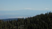
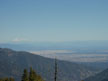
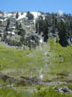
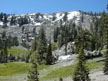
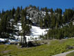
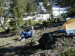
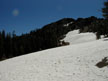
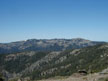
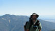
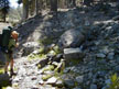
The Yolla Bolly wilderness is located east of Red Bluff California in the Mendocino National Forest. I have been looking at hiking this area for some time but the driving time always intimidated me. After all, it's 170 miles from Sacramento to the trailhead. The map that I have says that it is a two and a half hour drive from I-5 with the last 20 miles on gravel. With the snow still heavy in the Sierras I decided to head on up for the Fourth of July weekend and I wasn't disappointed. First of all let me say that the drive took me about 3 1/2 hours which is about what it would take me to go to Yosemite. And those gravel roads were the best I've seen in a long time. There are a lot of logging trucks using the same roads so they take care of them. We even saw two water trucks on the road making an attempt to keep the dust down. The last two miles to the trail head were the worst but I had no problem doing them with my Honda. One of the biggest sunrises awaited us at the trail head, there wasn't anyone else there. In fact we didn't see anyone the whole trip till the last day and we saw them within half a mile of the car on the fourth of July and they were just day hiking. I found that a three day weekend is ideal for the hike we did. It gave us plenty of time to drive up from Sacramento and hike in and make camp. Hike 8 miles the second day. And finish up with a two hour hike back to the car in time for a leisure drive back home. We could have easily have driven up the night before and made camp at or near the trail head. We hiked what is known as the Ides Cove Trail which is about a 15 mile hike. Since we arrived about noon we hiked about two hours to Long Lake(little camping at the lake but some spots higher up) which is a nice little lake with waterfall at the outlet. The prettiest lake is Square lake which is about an hours hike from the trail head and has good camping. The Ides Cove Trail continued on past a signed junction of the South Yolla Bolly Mountain Trial which doesn't appear on my map but appears to be the same unmapped trail which started at the trail head. From this junction the trail continued along the side of a few peaks before dropping down to double back to the trail head via a lower trail. This lower trail doesn't have the views of the upper trail but makes for a good loop. It also doesn't get as much use which would account for the condition of the trail. With the tight budget it's obvious that the Forest Service is spending it's money elsewhere. The South Yolla Bolly Mountain trail looked like it might be a good trail if you wanted to use that as a loop. Early in the season you would be able to get drinking water from the snow but I wouldn't count on it till you got there and had a look. The lower portion of the Ides Cove Trail isn't hard to follow but don't expect it to be anything like the well engineered trails in the Sierras which have easy grades, the grades of some of the trail in the Yolla Bolly can be steep(excluding the upper portion of the Ides Cove Trail). We had excellent views of Mt Shasta and Mt Lassen across the Sacramento Valley. At night we could see lights down from civilization but Mike(my hiking partner for this trip) was loving the nice dark sky for viewing the stars. |