 |
|
| |
|
|
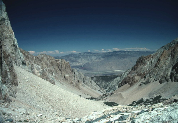
Taboose Pass may not be your first choice of places to start your hike but it will certainly get you to some remote places. Many people chose this pass to do an easy (if you can call it that) hike to the top of Mt Sill(14,062ft) Its rated at a class 3 so no ropes are needed. Its a lot of uphill as you start out doing about a 6000 ft climb just to reach the top of Taboose Pass and most of its loose talus with few places to camp but I enjoyed my two nights nearby. You could use one of several individuals listed to drop you off here.
To trailheads on the eastern side - If you're heading to Mt Whitney you might be able to hitch hike from Lone Pine. I've hitch hiked in Yosemite with mixed results however, I've had excellent results hitch hiking along Highway 395. I had a backpack and had just finished hiking 175 miles so I looked the part however, two guys in Bishop that weren't backpackers and were just hitch hiking. They told me no one was picking them up. I walked to the edge of Bishop and stuck my thumb out and had a ride in 15 minutes from a couple getting ready to go hiking. I was hitch hiking from south of Big Pine to Yosemite and my first ride took 30 minutes and the rest took about 15 minutes. If you don't want to hitch hike you can try this list of shuttles provided by the Sierra Clubs Loma Prieta Chapter. There are several people that run shuttles to trailheads but don't expect them to be cheap. YARTS - Yosemite Area Regional Transportation System, they make runs from Merced to Mammoth and stop at several trailheads. INYO MONO TRANSIT - Routes from the Reno Airport down highway 395 to Lancaster Greyhoud/Metrolink station. RENO/TAHOE INTERNATIONAL AIRPORT - the airports website www.395.com - anything and everything having to do with the east side of the Sierras and highway 395. TRAILHEAD SHUTTLES - A Sierra Club site that list shuttle information for the highway 395 and to the trailheads. |
| |
|
