 |
|
| |
|
|
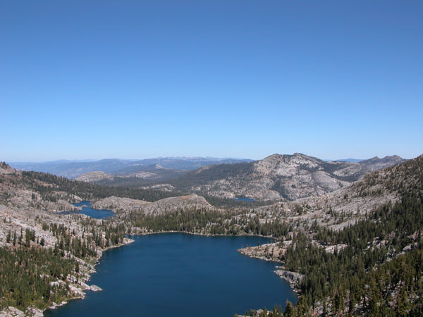
One area accessable by public transportation is shown above. This picture of Dicks Lake taken from Dicks Pass is about a 7 miles hike from Emerald Bay. You can reach Emerald Bay using public transportation as shown below. GETTING TO LAKE TAHOE AND TRUCKEE - There are several ways to the Lake Tahoe area. One way is to fly into Reno. If you flew into the Reno Airport you can take the South Tahoe Express to South Lake Tahoe. This bus drops people off at several of the Casinos. The No Stress Express also runs from the Reno Airport to the Lake Tahoe Area. At the time I'm writing this they have a route to the North and South Lake Tahoe areas but the route to Truckee has been cancelled. Thats ok since it will take you to North Lake Tahoe where you can hook up with TART. You can also take Greyhound or Amtrak to downtown Reno but I can't find any transportation from there to the Lake Tahoe area. Greyhound and Amtrak both make stops at Truckee so that would be your best bet if you wanted to go to the northern part of Tahoe. HIKING IN THE NORTH TAHOE AREA - If you're going backpacking the easiest connections to trails is at Tahoe City where the Tahoe Rim Trail comes down to the Truckee River. From the brocher that TART has it looks like the bus goes as far at Sugar Pine State Park but from the schdules it doesn't look like thats the case. Most of the area near here only requires a campfire permit but if you're hiking into the Desolation Wilderness from the north you'll need a permit. For more information on permits in the Truckee area check out the Tahoe National Forest website and look under the FAQ's. HIKING IN THE SOUTH LAKE TAHOE AREA - If you're going to the South Lake Tahoe area and want to go backpacking it looks like the best thing to do is to take the Nifty 50 Trolley. You'll probably have to transfer a few times but it will take you to Emerald Bay where you have access to the Desolation Wilderness. As I write this the official page for the trolley isn't up as its winter. It looks like route B takes you past the Ranger Station so you could stop and get a permit. To find out more about permit scheck out the Eldorado National Forest website. You'll find out more about permits under the FAQ's. TAHOE YOSEMITE TRAIL - The Tahoe Yosemite Trail starts at Meeks Bay. You can now reach the trailhead from either direction. From South Lake Tahoe you can take the Nifty 50 trolley to Emerald Bay, stopping at the Ranger Station to get a permit. You'd then have to catch the North Shore Trolley to Meeks Bay or, if you don't care about hiking the first part of the trail you could hike from Emerald Bay west to the trail. From the North Lake Tahoe area you can take the North Shore Trolley toward Emerald Bay.
INYO MONO TRANSIT - Routes from the Reno Airport down highway 395 to Ridgecrest. RENO/TAHOE INTERNATIONAL AIRPORT - the airports website Reno/Tahoe International Airports Transportation links - List of transportation from the airport Lake Tahoe Transit- Or the North Lake Tahoe Express. They have a bus around the north shore of Lake Tahoe, all the way to Emerald Bay. If you're doing the Tahoe Yosemite Trail jump off at Meeks Bay, or cheat and get off at Emerald Bay. Free Emerald Bay shuttle in summer. South Tahoe Express - bus service from the Reno Airport to the South Lake Tahoe area. No Stress Express - Transportation to Truckee and South Lake Tahoe ( Check to verify their routes!) TART - South Lake Tahoe Map - a map of the area showing bus stops BlueGO - In Summer the trolly connects to the Lake Tahoe Transit at Emerald Bay (E Route) |
| |
|
