 |
|
| |
|
|
|
|
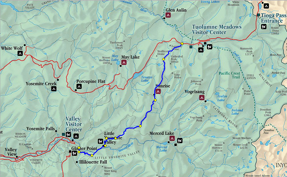
Hundreds of people a day hike the first 3 1/2 miles of this route each day to see the waterfalls. After leaving the top of the falls the number of people drops rapidly. Early in the morning you'll see a number of people heading to the top of Half Dome. If you care to make an attempt at breaking the record its 2 hours and 38 minutes set by Hari Mix. Some people only hike in about a mile till they can see Vernal Falls from the bridge, and some continue to the top of Vernal Falls via the Mist Trail, a trail I'll never recommend if you're carrying a backpack. Some of those people continue up to the top of Nevada Falls. People have gone over the top of the falls so don't get too close while in the river. The trail that remains close to the river is the hardest. The John Muir Trail uses the other one. Unfortunately this trail was paved at one time to the top of the falls so its hard on the feet. At the top of Nevada Falls you reach whats called Little Yosemite Valley. A number of people hike only this far and stay in the backpackers camp, a place I try to avoid. If you're continuing up the Merced River you must hike the length of Little Yosemite Valley on a sandy dusty trail for about 4 miles till you are allowed to camp. Continuing on the John Muir Trail you'll need to hike another 2 miles till you reach another place to camp near the junction with the Clouds Rest Trail, a popular place for bears too. From there you'd continue on a gentle climb for about 3 miles on the remains of an old lateral moraine till you start climbing again. This lateral moraine is about 2000 feet above the river below, which gives you an indication of how deep the glacier was in this area. Approaching Sunrise High Sierra Camp you'll get some great views of the surrounding peaks. The hiking from Sunrise High Sierra Camp to Tuolumne Meadows is an easy one, with an easy climb to the highest point on the trail. You'll also get great views of Cathedral Peak along the way, and pass Cathedral Lakes. Camping is not allowed at the lower lake. Its an easy descent to the highway in Tuolumne Meadows. Unless you've parked your car there you'll either have to hike the remaining distance to the the store, which is also near the junction with other trails, or take the free shuttle. At the store you can find plenty of supplies, and there is also a post office so you can mail food to yourself if you're on a long hike. There is also a backpackers campground here. You'll need a hiking permit to stay there. Things may have changed, but every time I've used it I've registered at a stone building just west of the river. This same stone building is also used by winter rangers. Their reports are available on Yosemite website and they'll include stuff like animals seen, avalanche dangers etc. They may not be there all the time, as they do go on patrols. Tuolumne Meadows is also a popular destination in winter. The winter of 2007/2008 is the first in a long time where to road to the east entrance wasn't plowed since a resort there didn't open. It remains to see if that continues in the future. If the road is plowed its a downhill ski into the meadow, and one of the classic ski trips is to continue following the highway either to Crane Flat, or to Yosemite Valley via the Snow Creek Trail, the only trail into the valley that remains open in winter due to the sun that shines on it. |
| |
|
