|
|
|
|
|
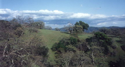
This is a picture I took on a previous hike at Henry Coe. It was taken in April which is a good time to go there as everything is green and there are fewer people. This is taken from the Springs Trail which starts at the headquarters. The trail is just visible on the far hillside, just look for the faint line on the side of the hill. According to Lee Dittmann, Mt. Sizer was the highest point until the big land purchases of the mid-80s added on land to the south and east. Since then, the highest point has been the side of a mountain at the extreme north end of the Orestimba Wilderness, a point approximately 3560 feet high. (You could call it a "shoulder" of Mt.Stakes, which is a mile north of this point.) The lowest point in the main body of the park is in the southeast corner, where the North Fork Pacheco Creek exits the boundary at elevation 710. The actual lowest point is at the Bell Station entrance with an elevation of about 350. The dirt road from this entrance and the accompanying right-of-way, along with roughly 20 acres at that entrance are all a part of the park. One thing to note is that the state recently purchased
some land on the south side of the park. The Dept of Fish &
Game has gotten most of that land however, the Dept. of Parks
& Recreation has possession of some of that land which will
be added to Henry Coe. I believe that some of this land will
be used to make a more permanent southern entrance. |