 |
|
| |
|
|
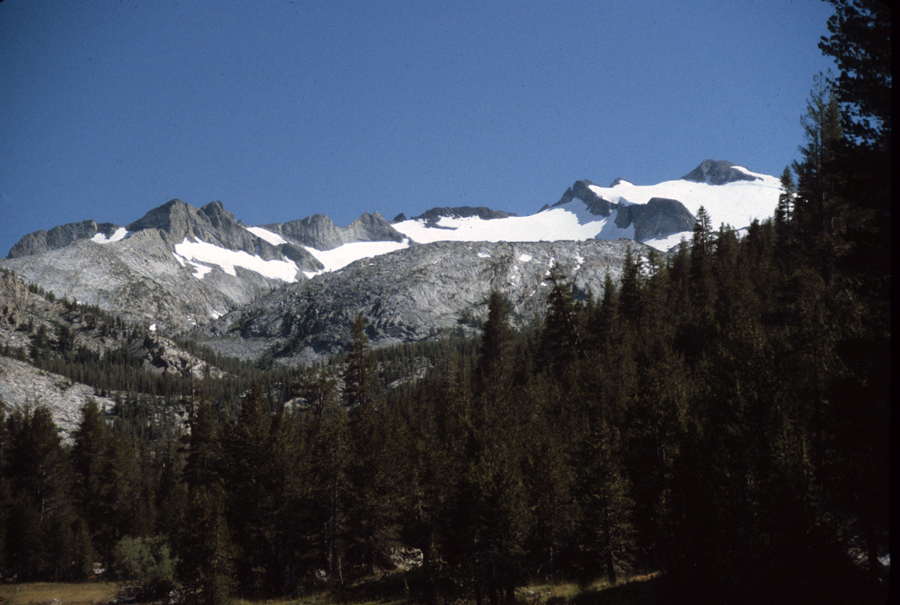
The worst part for me about moving from California is being unable to drive up into the Sierras for the day. I've moved a long ways away but I know I'll be back. I still want to hike the whole John Muir Trail in one hike, something I've tried several before but I've always run into problems. I remember the second time I tried it. I parked my brand new car in the parking lot at Curry Village in Yosemite Valley and came back 3 weeks later to find a dent in the drivers door. I can just see someone in a big pickup squeezing into a spot next to my car and slamming their door against mine. When I make my next trip to the Sierras it won't be with my car. I've used the buses in Yosemite before and I will again. I've found that its actually quite easy to get from some of the airports around California to the trailhead. It might take longer but I don't have to worry about someone denting my car. Besides, after a long hike it will be nice to sit back and let someone else do the driving. One popular hike that is done with public transportation is to take the bus from Yosemite Valley to Tuolumne Meadows and then hike back to the valley. The above picture is taken near above Vogelslang High Pass looking back toward Tuolumne Meadows. After passing over the pass its all downhill to the Valley. Don't think that's good. Its a bone jarring walk but the views are pretty good. Yosemite can be reached easily from several airports in California and Nevada. The west side of Kings Canyon and Sequoia National Parks on the other hand aren't as easy to get to. From the west side one would have to rent a car to drive to places other than Yosemite. There is no public transportation from the airport in Fresno but you can rent a car. Yosemite National Park is serviced by buses from Merced California several times a day. San Francisco Bay Area and Sacramento to Yosemite Los Angeles to Yosemite or the East Side of the Sierras Reno to the East Side of the Sierras Transportation in the Lake Tahoe area Transportation from Fresno to the West Side of the Sierras YARTS - Yosemite Area Regional Transportation System, they make runs from Merced to Mammoth and stop at several trailheads. Rideshare Information - transportation options in Merced County. Currently the airport is only serviced from Fresno by Scenic Airlines. At least that's what their website says. I can't find that airline listed for the Las Vegas Airport. Fly Fresno - Information on the Fresno Yosemite International Airport, including a list of airlines that fly there. There is no public transportation to the Sierras but you can rent a car. Inyo Mono Transit- Routes from the Reno Airport down highway 395 to Ridgecrest. Kern Regional Transit - Kern County has transportation between Mojave and Ridgecrest. Mojave can be reached by Amtrak's feeder bus or Greyhound. Reno/Tahoe International Airport - the airports website www.395.com - anything and everything having to do with the east side of the Sierras and highway 395.(not sure if this site is still working. If not it just went down) Trailhead Shuttles - A Sierra Club site that list shuttle information for the highway 395 and to the trailheads. Bay Area Rapid Transit System (BART)- You can use BART to connect with Amtrak from the Oakland and San Francisco airports. Yolo Bus - The number 42 bus will take you from the Sacramento International Airport to within a block of Amtrak or to Greyhound. Make sure you're on the bus going to Sacramento and not Davis. Amtrak - Amtrak's homepage. Sometimes they'll put you on a bus that will connect to a train. For example, you'd travel by bus from Sacramento to Stockton where you'd get on a train to Merced if you were to go to Yosemite. Greyhound - Greyhounds homepage for bus service San Francisco International Airport Sacramento International Airport Los Angeles International Airport Metropolitan Transit Authority - Los Angeles transit system Las Vegas - McCarren International Airport California Transportation links South Lake Tahoe Map - a map of the area showing bus stops Vermillion Valley Resort - well known resort at Edison Lake just off the PCT. Operates a shuttle to the Fresno Airport and bus/train station |
| |
|
